Babuyan Claro, Philippines Location:
19.50N, 121.95E |
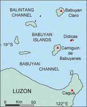
Babuyan Claro is a heavily forested stratovolcano near the center of Babuyan Island. The volcano has erupted at least 8 times since 1652. Six of these eruptions have been at Smith Volcano, a vent on the west part of Babuyan Island. Smith Volcano is a well preserved symmetrical cinder cone. The 1831 eruption of Babuyon Claro was the largest (VEI=4) and caused damage. The most recent eruption was in 1924 at Smith Volcano. Babuyan Claro, with twin craters oriented along an E-W line, occupies the central part of Babuyan Island. It is the youngest of five Pleistocene to Holocene volcanic centers on the island. The symmetrical cone of Smith Volcano (Mount Babuyan), located 4 km to the NW of Babuyan Claro, rises to 670 m. Both volcanoes have been active in historical time, although the identity of the erupting volcano is not always certain. |
Map from van Padang (1953).
Camiguin de Babuyanes, Philippines Location: 18.8N, 121.9E Camiguin de Babuyanes is a stratovolcano that forms the southwestern end of Camiguin Island. Most of the volcano is
covered by forest. There has been a single historic eruption on the southwest flank prior to 1857. The eruption was |
Links and Sources of Information:
|
The Babuyan group of islands, which include the islands of Calayan, Babuyan, Dalupiri, Balintang and Camiguin, has a mixture of flat to nearly level land, and steep to very steep slopes. These islands have extensive coral reefs. There are three volcanoes in the Babuyan Islands: Mount Didicas off Camiguin island, which has a symmetrical cinder cone, about 215 meters above sea level, and Mount Pangasun in Babuyan island, which is about 840 meters above sea level and has two craters and Babuyan Claro Stratovolcano with Smith Volcano Another volcano found in
Cagayan is Mount Kagua in Gonzaga in the northeast. It is being considered as a potential source of geothermal energy. The Babuyan Islands, about 40 to 60 km north of the Luzon mainland, are part of Cagayan. The group is noted
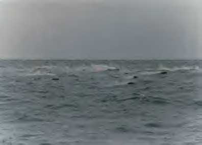
for active volcanoes, such as Babuyan Claro and Camiguin Volcano. Didicas Island was once known as Didicas Rock until a submarine volcano erupted in 1952 and formed the island.
|
Die Inselgruppe der Babuyan Inseln zu denen die Inseln Calayan, Babuyan, Dalupiri, Balintang und Camiguin gehören, bestehen aus einer Mischung von ebenem Land und äußerst steilen Felssteigungen. Diese
Inseln haben umfangreiche Korallenriffe. Es gibt dreii Vulkane auf den Babuyan Inseln: Mount Didicas vor der Insel Camiguin, die einen symmetrischen Aschekegel hat, ungefähr 215 Meter über Meeresspiegel und Mount Pangasun
auf der Insel Babuyan Island, der ungefähr 840 Meter über Meeresspiegel ist und zwei Krater hat, sowie Mount Babuyan Stratovolcano mit dem Smith Vulkan auf der Westseite Ein anderer Vulkan, der in
Cagayan gefunden wird, ist Mount Kagua(Cagua) in Gonzaga im Nordosten von Luzon. Es wird als mögliche Quelle geothermischer Energie betrachtet. Die Babuyan Inseln, ungefähr 40 bis 60 Kilometer nördlich des Festlands
von Luzon, sind ein Teil von Cagayan. Die Inselgruppe findet wegen der aktiven Vulkane, wie Babuyan Claro und Vulkan Camiguin Beachtung. Die Insel Didicas war einmal nur als Felsen Didicas
(Didicas Rock) bekannt, bis ein Unterwasservulkan 1952 ausbrach und die Insel Didicas bildete. |
Didicas
19.077°N, 122.202°E; summit elev. 244 m All times are local (= GMT hours) Didicas volcano, 22 km NE of Camiguin Island, was a submarine volcano prior to 1952, when a permanent island was formed. Didicas now consists of a
small, 244-m-high lava dome about 1.4 km in longest exposed dimension with a 400-m-wide crater. The first recorded eruption of Didicas was in 1773. An earlier cone of fragmental material reached a height of 213 m in 1860, after a
four-year-long eruption, but soon was eroded beneath the sea. Three rock masses were left after an eruption in 1900. Two eruptions have occurred since 1952 at an explosion crater on the north side. http://nmnhwww.si.edu/gvp/volcano/region07/luzon_n/didicas/var.htm |


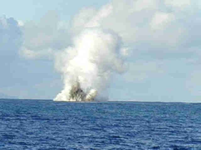
Underwater Volcano is coming up, rising to an Island Volcano.
Phraetic Explosion (Painting)

Malapascua Island

Visayan Sea, Cebu, Philippines,
